The Systems Engineering program faculty conducts research in numerous fields which are listed below. As an MS student, you will gain tremendous exposure to the topics below, which are at the forefront of research and technology, through the classes you will take (which build partially on these research activities), and through direct exposure to the research work through projects or Graduate Student Research appointments.
 Adaptive System-Level Bridge Management Decision-Making
Deterioration models deployed in Bridge Management Systems (BMS) to determine optimal Maintenance, Rehabilitation and Reconstruction (MR&R) polices are developed from bridge condition data. The low resolution and coverage of these data sets have produced inaccurate models and significant lifecycle cost increase. This research applies adaptive control to successively improve the deterioration models over time, and to improve MR&R decision-making. Stochastic Duration Models are used and updated by Open-loop Feedback Control. Results have shown improvements relative to Certainty-Equivalence Control methods and time-invariant Markov Models used in current BMS. The benefits of this approach are evaluated through an ongoing empirical study.
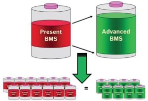
Advanced Battery Management Systems
We are developing battery monitoring and control software to improve the capacity, safety, and charge rate of electric vehicle batteries. Conventional methods for preventing premature aging and failures in electric vehicle batteries involve expensive and heavy overdesign of the battery and tend to result in inefficient use of available battery capacity. The objective is to increase usable capacity and enhance charging rates by improving the ability to estimate battery health in real-time, to predict and manage the impact of charge and discharge cycles on battery health, and to minimize battery degradation.
 Clean Energy from Hot Dry Rock
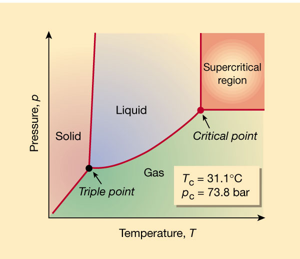
The Earth produces enough thermal energy to meet human demands many times over, but geothermal energy production has been limited to a few ideal locations. Engineering solutions can allow us to unlock the geothermal energy under conditions where water does not flow freely through hot rock. Using a specially constructed laboratory apparatus, we are exploring the use of supercritical CO2 (a pervasive greenhouse gas) instead of water as the geothermal circulating fluid in order to increase energy production by 80% and to allow production at locations that are not ideal for conventional methods.
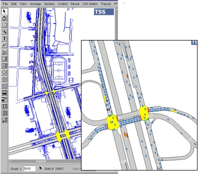
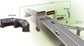
The Connected Corridors program is a collaborative effort among a range of stakeholders - including the California Department of Transportation - to research, develop, and test a framework for corridor traffic operations in California. Connected Corridors is investigating how corridor components (highways, arterials, buses and rail) can work together efficiently so they can be managed as an integrated system, to reduce congestion and improve mobility. Connected Corridors will leverage new technologies: the internet, cellular and mobile devices, GPS technology, and social networking; along with building on the exeprience from previous PATH projects, including Tools for Operational Planning (TOPL) and Mobile Millennium.
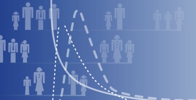
Fundamental to any research are the statistical tools that are used to model behavior, and therefore a significant part of my research is focused on improving these methods. There are issues with how models are specified, in particular the weak connection with the way people make decisions. I work to develop tools that enable more realistic specifications of the behavior. There are also issues with the methods being applied incorrectly, and I do work to uncover and fix these mistakes.
This project builds an accurate activity-based simulation of traffic movement within Ireland. The simulation relies on MatSim simulation software and incorporates multiple data sources from population census and national transportation agencies. The model also uses social media and the geography of the social network to study social influences in activity choice and travel behaviours.
 The Floating Sensor Network is a water monitoring system which integrates mobile robotics platforms (motorized drifters) and live feeds of the Sacramento San-Joaquin Delta in California. The mobile floaters integrate a suite of sensors (GPS, salinity, temperature, etc.), and communicate to the ground through the GSM network and with ZigBee radios. They are deployed for finite duration missions and send data about the currents to a data assimilation system which integrates the streaming data into hydrodynamic models developed by LBNL, to produce real-time nowcast of the currents in the Delta.
Highway Pavement Network Resurfacing Policy
Traditionally, pavement management optimization has focused on minimizing user and agency costs. Previous research has expanded beyond minimization of life-cycle costs, to also include GHG emission, by solving the multi-criteria optimization problem with two objectives. Case studies were performed for an arterial and a major highway to highlight the contrast between policy decisions for various pavement and vehicle technologies. The current research aims to extend the multi-objective optimization methodology (with life-cycle costs and GHG emissions) to the management of an entire highway network in the presence of realistic constraints.
i2maps is an open-source software project. It provides a programming framework for interactive web visualisation and knowledge discovery from spatio-temporal data. It combines JavaScript and Python libraries to present the results of your data analysis quickly and easily to your target audience.

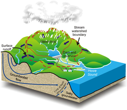
It is estimated that seasonal snow cover is responsible for 80% or more of annual water supplies in California. Stewardship of the state’s valuable water supply requires understanding of the mountain hydrology system from the first snowfall to the water in your tap. We are operating two of the largest wireless sensor networks in the world - a 60-node wireless sensor network, (> 280 sensors) near Shaver Lake, CA and more than 250-nodes in the American River basin (> 1200 sensors), allowing investigation of the effects of local-scale phenomena on large-scale mountain hydrology, something which is unfeasible without the WSN.
Turn your iPhone into an earthquake-measuring device and get live maps of other users' shakes! UC Berkeley is conducting research on the validity of modern smart phones being used as mobile earthquake sensors. Contribute your phone as a sensor to the project. Simply turn the application on when you plug in your phone at night and any possible earthquake triggers measured by your phone will instantly be streamed back to our University servers for further processing and map generation.
Through carefully controlled experiments, fundamental mechanisms of fault rupture initiation are being studied with a level of detail unimaginable in the field. This is made possible by sensors designed in the Glaser lab. These devices allow accurate measurement of displacements as small as 1 pm, over a wide frequency band; no other displacement sensor can match this performance. Current work includes scaling effects of near-fault measurement on perceived source dynamics, localized precursors to rupture, and nano-friction.
Large-scale Urban Model Systems
This is the most applied area of research that I work on and is motivated by my time in industry (4-plus years at Caliper Corporation, 2-plus years as their Director of Demand Modeling). My emphasis here is to make use of the advances in the methods for modeling behavior and our increased understanding of behavior to improve the large-scale urban model systems used to inform decision-making regarding infrastructure investment and transportation policy. I work in both the developed and developing world contexts.
Learning Spatial Human Dynamics
This project builds machine learning models to uncover the complexity of urban mobility and the interplay between social networks and population movements in cities at a variety of temporal and spatial scales.
Maintenance Management for Bridge Networks
The research addresses the problem of optimizing maintenance, rehabilitation decisions for deteriorating bridges in highway networks. We search for the optimal maintenance plan which ensures an adequate level of network reliability at the lowest possible life-cycle cost. We show that the network reliability function can be obtained directly from the minimal cut sets under reasonable approximations. Analytical and efficient approaches are developed for networks with multiple origin-destination pairs. We also investigate large scale networks with the objective of minimizing the disruption to traffic caused by bridge failures by decomposing the network-level problem into single facility problems.
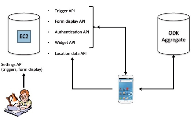 This project, led by Aluma Dembo and Sid Feygin, uses XMobile to test economic theories on decision making. The researchers take a graphical interface first developed for the computer and implement it in the mobile phone environment. The graphical interface, developed by Investigator Kariv, has been validated over repeated experiments and thousands of subjects as a means of effectively measuring economic decisions at the individual level [Choi et al., 2006; 2007.] For this XMobile project subjects are prompted to make decisions on their mobile phones at random times throughout the week. This experiment uses revealed preference techniques to test whether rationality and preferences are the same "in the wild" as in the laboratory. Additionally, this study attempts to explain decisions using the rich set of information available on the mobile phone.
![]() Mobile Millennium
Mobile Millennium
...
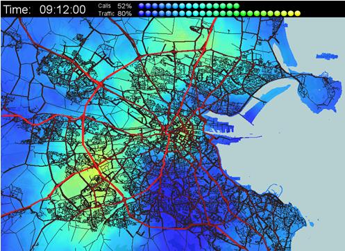
Mobile Millennium is a traffic monitoring system which fuses streaming data from mobile and static sensors in real-time, to produce traffic estimates faster than the physics of traffic. It started as a smartphone based system, launched in 2008 jointly with Nokia. Today, it integrates dozens of data feeds totaling millions of data points every day feeding our system. It produces real-time estimates of traffic on all highways and major arterial roads in Northern California. A live visualizer is accessible to the public in the CITRIS museum at the CITRIS headquarters on the UC Berkeley campus.
Monitoring Flexible Loads for Demand Response
 This research investigates a new paradigm for monitoring demand response (DR) enabled loads. We examine the application of partial differential equation (PDE) models for estimation and control. Specifically, we model the dynamics of thermostatically controlled load (TCL) populations, instead of modeling each TCL individually. This aggregate modeling approach produces elegant algorithms that are simple to implement, high performance, and robust. Ultimately, these algorithms advance current approaches by requiring minimal sensing infrastructure, providing unprecedented monitoring detail, and enabling predictive control for integrating variable renewable power. This project generates experimental data to test the feasibility of these algorithms. Moreover, it enhances sustainability efforts on UC campuses.
Making a water secure world is becoming the watchword of the 21st century – security of supply and quality, security from water-driven natural hazards, security of fragile ecosystems. Watershed degradation in the Philippines is becoming severe, affecting livelihoods, particularly for those who depend on farming and forestry activities. The Internet of Water will build and operate hardened hydro/geo observatories that will provide detailed, comprehensive and real-time information on surface and subsurface hydrologic conditions, local meteorological conditions, vegetative state, and ground movements of the watersheds. Experimental sites include the Molawin-Maralas catchment and the Dampalit watershed, within the Mt Makiling Forest Reserve.
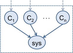
Many of our nation’s critical infrastructure systems are aging and becoming increasingly unreliable. How do we ascertain which of the multitude of components comprising a system are the most critical? In our research, we are creating algorithms that enable us to model large systems in a probabilistic manner, specifically, as a Bayesian network. In an environment where information about a system is uncertain and evolving over time, for example, after a natural or man-made disaster, this powerful framework is ideally suited for risk assessment and to support decision making for our nation’s complex infrastructure systems.
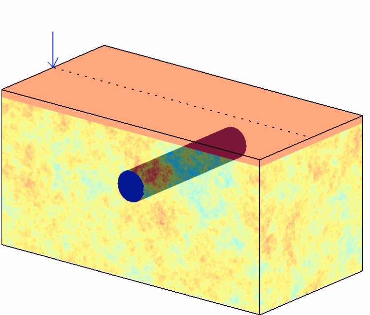
Seismic Tunnel Detection Methods
The detection of unknown tunnels and other underground openings is a challenging problem in geophysics and has implications for geomechanical design, public safety, and domestic security. We are investigating a number of different seismic techniques that show promise in addressing these challenges: surface wave backscattering, body wave diffraction, resonant wave imaging, and attenuation tomography. In particular, we are interested in the limitations of these methods with regards to the target object’s depth and size, and the effect of naturally occurring geological heterogeneity on their resolution.

Structural health monitoring (SHM) studies the health of buildings over time. In this project, we use sensors to predict the response of a building to an earthquake. In our methodology, we combine our prior knowledge about the building with new information we obtain from sensors mounted on the building to dynamically monitor the structure. Our framework analyzes the evolution of the building probabilistically, informs decision making on the design of SHM strategies, and supports smart decisions about structural systems.
Within the domain of transportation, predicting travel behavior is critical for improving the models that are used to evaluate infrastructure plans and policies. I work to incorporate factors into the models that are believed to be important in behavior and yet are not generally included. I have focused on social influences, the role of information, attitudes towards the environment, and higher-order lifestyle orientations.
 This project led by Andre Carrel is working on a study to understand the link between transit reliability, service quality and ridership retention. The study aims to demonstrate the extent to which reliable transit service can contribute to ridership retention, and vice versa. A cohort of 200 to 1,000 San Francisco residents will be recruited, which will include both regular transit riders and non-riders (auto users). Auto users will commit to using public transportation for at least a week during the study period. The XLab Mobile infrastructure will be used to collect location data from participants in order to reconstruct travel diaries, and to periodically ask them to answer surveys on the trip quality they experienced when using public transportation.
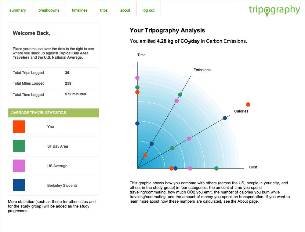
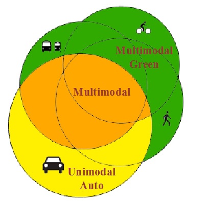
This follows directly from travel behavior modeling, because once we understand what drives behavior, we can work to shift individual’s travel in more desirable directions (including more sustainable and healthier). Our Quantified Traveler project tracked individual’s travel via smartphone, fed back information on resources spent traveling (time, money, emissions, and calories) along with social comparisons of how much other people spent. In the three week experiment, we saw a measurable shift away from driving and towards biking and walking.

This project led by Nachi Mehta is inspired by UC Berkeley’s WorkFit program to help make fitness and healthy eating easier for both participants of the program and their instructors. The benefit of harmonizing technology and fitness is two fold in this case, not only are participants able to keep on track with their fitness and diet goals, but instructors are able to see real-time data for their clients. With more information at their fingertips, instructors are better able to individualize programs and better able to help their clients achieve success.